
INTERVIEW & VIDEO: Discovery Channel looks into the tragedy of Hurricane Sandy

Discovery Channel is set to tackle Hurricane Sandy on its successful Curiosity series on Sunday, Nov. 18 at 9 p.m. The episode, titled “Megastorm,” looks at how Sandy originated and forever changed the New Jersey and New York coastlines.
Jason Dunion, a meteorologist specializing in satellite remote sensing of hurricanes, is featured on the program and recently exchanged emails with Hollywood Soapbox. Below is the interview.
What’s the greatest lesson we can learn from Hurricane Sandy?
Hurricane Sandy reminded us that storms come in many different flavors … each with its own challenges. 2011 Hurricane Irene brought significant inland flooding (as much as 15-20 inches) and strong winds that tested our power grids. Just one year later, Hurricane Sandy once again brought powerful winds to the Northeast, but will be most remembered for the incredible coastal flooding that it caused. The bottom line is that it’s important for folks living in hurricane-prone areas to always stay vigilant and be reminded that each storm brings its own unique challenges and dangers.

How unique was the storm, as far as hurricanes go?
Hurricane Sandy was unique in many ways. While it was brewing in the Caribbean, it went through a period of what we call rapid intensification. This means that its winds strengthened more than 35 mph in just 24 hours … A truly rare rate of intensification that is in the 95 percentile of all Atlantic hurricanes.
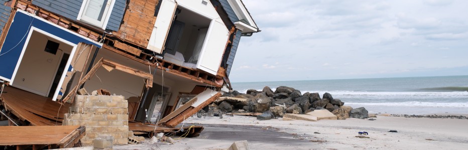
Another unique aspect of Sandy was its huge wind field: at one point, its tropical storm force winds spanned about 1,000 mile(s) — more than double the size of a typical hurricane. That’s an area equal to about 25 percent of the lower 48 states. Its track was also fairly unique: while most hurricanes that track up the east coast tend to be deflected out to sea, the steering patterns that were directing Sandy not only kept it hugging the coast, but actually forced it west toward the Northeast.
Finally, Sandy just happened to make landfall in New Jersey at the time of a full moon when the sun, Earth and moon all fall into alignment. This alignment creates enhanced tides, or spring tides, and in the case of Sandy, just added to the hurricane’s building storm surge. This created large storm tides of up to 12-14 feet that caused extensive flooding and damage along the Northeast coast. Given all of these unique occurrences, we wouldn’t expect a storm like Sandy to affect the Northeast more than once every 100+ years.

How did you become a hurricane chaser?
I think that love of the weather has been in my blood since I was a kid. When I was 8 years old, I remember Tropical Storm David hitting us up in New England — make no mistakes about it — I was pretty scared and ended up hiding underneath my pillow most of the night that it passed us by.
At the same time, I remember being fascinated by that storm. By the time I was 8, I had my own mini weather station. I took my first ride into the eye of a hurricane (Erika) when I was in graduate school — our planes were based out of Bermuda and it was an incredible flight. That experience made quite an impression on me … it’s (probably) no coincidence that my daughter’s name is Erika.
Is the tri-state area prepared for a Category 2 or higher storm?
Although it’s rare for a hurricane to reach the Northeast states as a category 2 or even major category 3 hurricane, it is certainly a real possibility. Recent experience with Hurricanes Irene and Sandy has probably helped significantly raise hurricane awareness for folks that live there. Still, the level of coastal evacuations that would be required for a category 2 or 3 striking the Northeast would be extensive and damage to homes, trees, and local power grids would be considerable. It’s certainly difficult to be totally prepared for a storm of that magnitude.
Still, residents and local, state, and federal agencies need to plan and be prepare for each hurricane season and will hopefully even have a slight edge with the experience of enduring Irene and Sandy.
Does climate change have anything to do with the storm cycles that affect the United States?
The evidence for climate change is overwhelmingly compelling, though how warmer climate might affect hurricanes is not clear. Some climate models suggest that hurricanes could better flourish in a warmer climate, while others suggest that the atmosphere could become more hostile to storms. Unfortunately, our hurricane records only date back about 150 years, and the more reliable record that includes aircraft and satellite data only dates back 50-60 years. From Mother Nature’s perspective, that’s truly the blink of an eye. Still, we should always be concerned about changes we make to our planet and the possible ripple effects those changes might cause.
By John Soltes / Publisher / John@HollywoodSoapbox.com
-
Curiosity airs on Discovery Channel Sunday night at 9 p.m.